April 13, 2024
NOAA Satellites View Total Solar Eclipse:
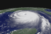
On April 8, 2024, the moon moved directly between the Earth and sun, completely blocking the sun’s light and causing a total solar eclipse. During this event, the moon’s shadow passed over parts of Mexico, the United States, and Canada, and millions of people were treated to a celestial show where the sky darkened as if it were dawn or dusk throughout its path of totality.
Solar eclipses occur when the moon passes between the sun and the Earth, casting a shadow on the Earth’s surface. There are three main types of solar eclipses:
• Total Solar Eclipse: This occurs when the moon completely covers the sun, blocking out its light entirely. During a total solar eclipse, the sky darkens significantly, and the sun's outer atmosphere, or corona, becomes visible. Total solar eclipses are only visible from a narrow path on Earth's surface, known as the path of totality. Outside this path, observers may see a partial eclipse.
These types of eclipses occur due to an amazing cosmic coincidence. The sun just happens to be about 400 times wider than the moon, but also just happens to be about 400 times farther away. Due to this, they just happen to appear the same size in our sky during a total solar eclipse. What are the odds? If the moon or sun were even a slightly different size or distance from Earth, this phenomenon would not occur.
However, as the moon orbits Earth, it is constantly drifting a little farther and farther away by a few centimeters every year, and its orbit is becoming wider. Due to this, one day, millions or even billions of years in the future, the moon’s position will move too far away to fully obstruct the disk of the sun and no more total solar eclipses will occur on Earth—only annular eclipses will be visible.
• Partial Solar Eclipse: In a partial solar eclipse, the moon only partially covers the sun, leaving a crescent-shaped portion of the sun still visible. The degree of coverage depends on the observer's location relative to the path of the eclipse. Partial solar eclipses are visible over a much broader area than total eclipses.
• Annular Solar Eclipse: An annular solar eclipse occurs when the moon is too far from the Earth to completely cover the sun's disk due to its elliptical orbit. As a result, a ring of sunlight remains visible around the edges of the moon, creating a "ring of fire" effect. Annular eclipses happen when the moon is near the farthest point from Earth in its orbit (apogee), and the Earth is near the farthest point from the sun in its orbit (aphelion).
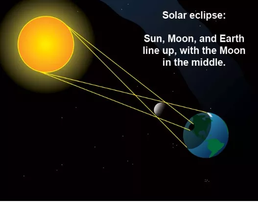
A drawn image of the sun, moon and the earth during a total solar eclipse.
Solar eclipses influence weather through various mechanisms, which include:
• Temperature Drop: As the moon blocks the sun, incoming solar radiation decreases, causing a drop in temperature. The greatest drop occurs in the path of totality, with reductions of up to 8 to 14 degrees Fahrenheit in dry environments. This cooling effect impacts air circulation and cloud formation. Additionally, the loss of light and temperature drop can cause local animals and birds to prepare for sleep or behave confusedly during totality.
• Cloud Dissipation: Solar eclipses can cause changes in cloud cover. For example, cumulus clouds may dissipate when only a small percentage of the sun is covered, leading to a temporary clearing of skies. This occurs because the sun heats the ground, so a lack of its heat will decrease the upward movement of moisture-rich air that forms these clouds. However, mid- and high-level clouds generally remain unaffected.
• Relative Humidity Increase: Despite no additional moisture, relative humidity rises during eclipses due to cooling air temperatures. This phenomenon is observed across various locations within the path of totality.
• Wind Changes: The passage of the moon's shadow creates localized wind patterns. As the air cools, it sinks, leading to changes in wind direction and speed. Researchers have documented variations in wind behavior during eclipses, including light winds switching direction and then becoming calm.
• Ionospheric Bow Waves: Total solar eclipses generate bow waves in the ionosphere, a layer of the atmosphere containing free electrons and ions. These waves, analogous to those produced by a boat in water, result from the rapid movement of the eclipse shadow through the atmosphere.
Although solar eclipses happen all over the Earth about twice a year, the next total solar eclipse is not predicted to occur in the United States until March 30, 2033, where it will be seen from northwestern Alaska. Another will occur across parts of Canada, Montana, and the Dakotas on Aug. 23, 2044. However, it won’t be until Aug. 12, 2045 when one will cross the contiguous United States from California to Florida.
Satellites play a crucial role in observing the effects of solar eclipses, as they offer a unique vantage point from space, free from atmospheric interference and the limitations of ground-based observations. Satellites equipped with specialized instruments and cameras capture valuable data and images during solar eclipses, providing scientists with important information.
NOAA’s GOES satellites viewed this eclipse from space, and were able to see the moon’s shadow moving along the Earth in near real-time thanks to the Advanced Baseline Imager instrument.
The VIIRS instrument onboard each of NOAA’s JPSS polar-orbiting satellites also captured the moon’s shadow on Earth as it traveled across the Northern and Southern hemispheres during the eclipse. Additionally, NASA's Earth Polychromatic Imaging Camera (EPIC) onboard NOAA's Deep Space Climate Observatory (DSCOVR) satellite also captured the event from roughly one million miles away.
NOAA satellites also captured the change in cloud cover as well as the effects of the eclipse shadow on surface weather. Land surface temperature data showed a drop of 8-12 degrees Fahrenheit as the eclipse shadow moved over land. Air temperatures dropped 5-6 degrees Fahrenheit in many places.
This summer, NOAA will be launching GOES-U, the fourth and final satellite in the Geostationary Operational Environmental Satellite (GOES) – R Series, the Western Hemisphere’s most sophisticated weather-observing and environmental monitoring system. The GOES-R Series provides advanced imagery and atmospheric measurements, real-time mapping of lightning activity, and space weather observations.
GOES-U will be different from its sister satellites, however, since it will be carrying a new instrument that mimics a total solar eclipse called the Compact Coronagraph-1 (CCOR-1). CCOR-1 is NOAA’s first-ever solar coronagraph, and will reside on GOES-U’s Solar Pointing Platform, along with other space weather monitoring sensors that include the Solar Ultraviolet Imager (SUVI) and Extreme Ultraviolet and X-ray Irradiance Sensors (EXIS).
CCOR-1 will monitor the outer layer of the sun’s corona, and will help detect and characterize coronal mass ejections (CMEs). These large eruptions from the sun hurl massive clouds of magnetized plasma far into space and are the primary cause of geomagnetic storms, which can cause widespread damage to power grids, satellites, and communication and navigation systems on Earth if we happen to be in the way.
The critical space weather information collected by CCOR-1 will ensure continuity of critical CME imagery to enable the National Weather Service Space Weather Prediction Center to issue warnings 1–4 days prior to damaging geomagnetic storm conditions.