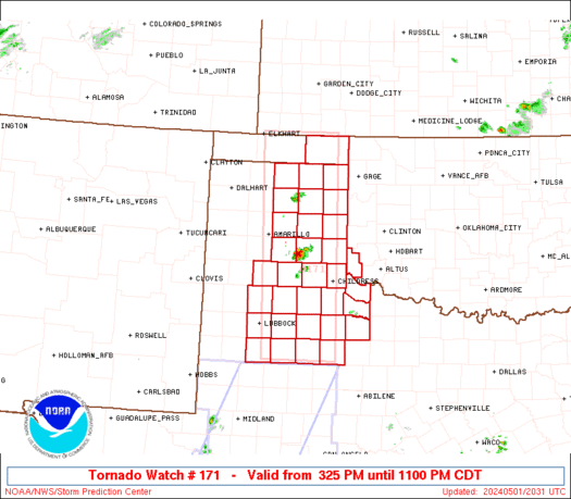
WW 171 TORNADO OK TX 012025Z - 020400Z
URGENT - IMMEDIATE BROADCAST REQUESTED
Tornado Watch Number 171
NWS Storm Prediction Center Norman OK
325 PM CDT Wed May 1 2024

The NWS Storm Prediction Center has issued a

* Tornado Watch for portions of
  Southwest Oklahoma
  Eastern Texas Panhandle

* Effective this Wednesday afternoon and evening from 325 PM
  until 1100 PM CDT.

* Primary threats include...
  A few tornadoes possible
  Widespread large hail and isolated very large hail events to 4
    inches in diameter likely
  Scattered damaging winds and isolated significant gusts to 75
    mph likely

SUMMARY...Widely scattered but intense thunderstorms are expected to
affect the watch area through the afternoon and evening.  Very large
hail, damaging wind gusts, and a few tornadoes will be possible with
these storms.

The tornado watch area is approximately along and 45 statute miles
east and west of a line from 5 miles west northwest of Liberal KS to
105 miles south southwest of Childress TX. For a complete depiction
of the watch see the associated watch outline update (WOUS64 KWNS
WOU1).

PRECAUTIONARY/PREPAREDNESS ACTIONS...

REMEMBER...A Tornado Watch means conditions are favorable for
tornadoes and severe thunderstorms in and close to the watch
area. Persons in these areas should be on the lookout for
threatening weather conditions and listen for later statements
and possible warnings.

&&

OTHER WATCH INFORMATION...CONTINUE...WW 170...

AVIATION...Tornadoes and a few severe thunderstorms with hail
surface and aloft to 4 inches. Extreme turbulence and surface wind
gusts to 65 knots. A few cumulonimbi with maximum tops to 500. Mean
storm motion vector 24035.

...Hart
WW 170 SEVERE TSTM TX 011825Z - 020200Z

URGENT - IMMEDIATE BROADCAST REQUESTED
Severe Thunderstorm Watch Number 170
NWS Storm Prediction Center Norman OK
125 PM CDT Wed May 1 2024

The NWS Storm Prediction Center has issued a

* Severe Thunderstorm Watch for portions of
  West Texas

* Effective this Wednesday afternoon and evening from 125 PM
  until 900 PM CDT.

* Primary threats include...
  Scattered large hail and isolated very large hail events to 3
    inches in diameter likely
  Scattered damaging winds likely with isolated significant gusts
    to 80 mph possible
  A tornado or two possible

SUMMARY...Thunderstorms will intensify this afternoon along the
dryline, tracking eastward through the early evening.  Very large
hail and damaging winds are possible, along with an isolated tornado
or two.

The severe thunderstorm watch area is approximately along and 60
statute miles east and west of a line from 55 miles north northeast
of Big Spring TX to 40 miles southwest of Dryden TX. For a complete
depiction of the watch see the associated watch outline update
(WOUS64 KWNS WOU0).

PRECAUTIONARY/PREPAREDNESS ACTIONS...

REMEMBER...A Severe Thunderstorm Watch means conditions are
favorable for severe thunderstorms in and close to the watch area.
Persons in these areas should be on the lookout for threatening
weather conditions and listen for later statements and possible
warnings. Severe thunderstorms can and occasionally do produce
tornadoes.

&&

AVIATION...A few severe thunderstorms with hail surface and aloft to
3 inches. Extreme turbulence and surface wind gusts to 70 knots. A
few cumulonimbi with maximum tops to 500. Mean storm motion vector
25030.

...Hart
WW 0171 Status Updates
STATUS FOR WATCH 0171 HAS NOT BEEN ISSUED YET
WW 0170 Status Updates
STATUS REPORT ON WW 170

THE SEVERE WEATHER THREAT CONTINUES ACROSS THE ENTIRE WATCH AREA.

FOR ADDITIONAL INFORMATION SEE MESOSCALE DISCUSSION 0591

..LYONS..05/01/24

ATTN...WFO...MAF...SJT...


STATUS REPORT FOR WS 170

SEVERE WEATHER THREAT CONTINUES FOR THE FOLLOWING AREAS

TXC003-033-043-081-103-105-115-135-151-165-173-227-235-317-329-
335-353-371-383-413-415-431-435-443-451-461-012240-

TX
.    TEXAS COUNTIES INCLUDED ARE

ANDREWS              BORDEN              BREWSTER
COKE                 CRANE               CROCKETT
DAWSON               ECTOR               FISHER
GAINES               GLASSCOCK           HOWARD
IRION                MARTIN              MIDLAND
MITCHELL             NOLAN               PECOS
REAGAN               SCHLEICHER          SCURRY
STERLING             SUTTON              TERRELL
TOM GREEN            UPTON


THE WATCH STATUS MESSAGE IS FOR GUIDANCE PURPOSES ONLY.  PLEASE
REFER TO WATCH COUNTY NOTIFICATION STATEMENTS FOR OFFICIAL
INFORMATION ON COUNTIES...INDEPENDENT CITIES AND MARINE ZONES
CLEARED FROM SEVERE THUNDERSTORM AND TORNADO WATCHES.
MD 0591 CONCERNING SEVERE THUNDERSTORM WATCH 170... FOR WEST TEXAS
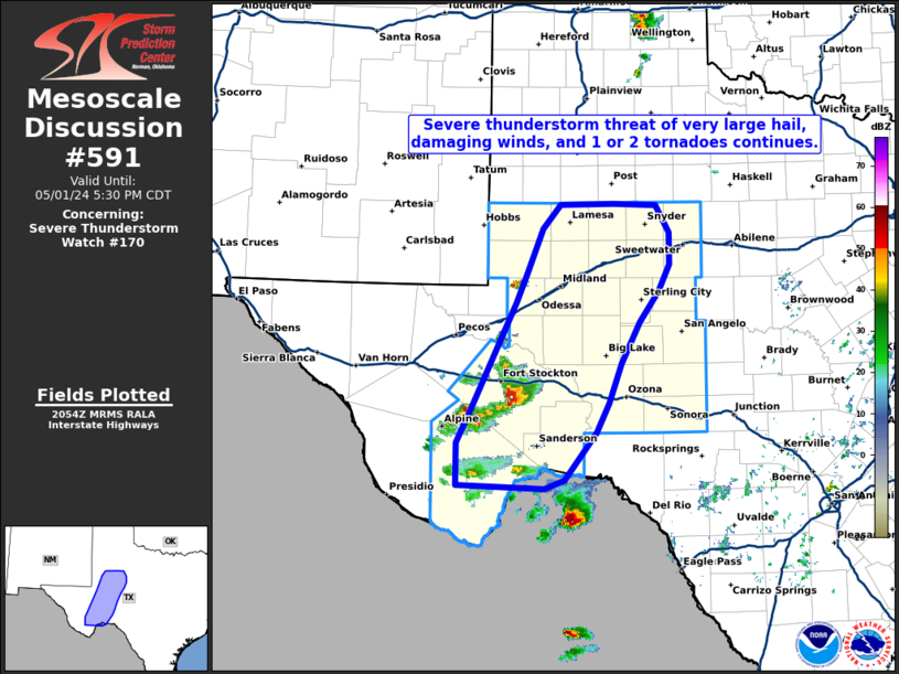
Mesoscale Discussion 0591
NWS Storm Prediction Center Norman OK
0357 PM CDT Wed May 01 2024

Areas affected...West Texas

Concerning...Severe Thunderstorm Watch 170...

Valid 012057Z - 012230Z

The severe weather threat for Severe Thunderstorm Watch 170
continues.

SUMMARY...A severe threat of very large hail exceeding 2 inches in
diameter and damaging wind gusts over 70 mph continues across most
of west Texas this afternoon. Additional supercells may continue to
develop along the dryline through the early evening hours.

DISCUSSION...Latest KMAF reflectivity shows a few supercells over
the higher terrain of west Texas near Fort Stockton and the Davis
Mountains. The regenerative supercell near Fort Stockton recently
deviated southward and may be in the process of tornadogenensis,
although low level shear remains relatively modest. Environmental
parameters across the region will continue to support organized
updrafts, especially near and south of Fort Stockton over the next
1-2 hours. Hail and damaging winds are likely, and the severe risk
continues across much of WW170.

..Barnes/Lyons.. 05/01/2024

...Please see www.spc.noaa.gov for graphic product...

ATTN...WFO...EWX...SJT...MAF...

LAT...LON   31790267 32140252 32660230 32930206 32950134 32930077
            32600059 32240058 31930073 31560099 31080124 30620141
            30280159 29740202 29630229 29670346 30170346 30540327
            31790267
MD 0590 CONCERNING SEVERE POTENTIAL...WATCH POSSIBLE FOR SOUTH CENTRAL TEXAS
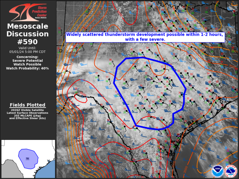
Mesoscale Discussion 0590
NWS Storm Prediction Center Norman OK
0333 PM CDT Wed May 01 2024

Areas affected...South central Texas

Concerning...Severe potential...Watch possible

Valid 012033Z - 012200Z

Probability of Watch Issuance...40 percent

SUMMARY...Widely scattered thunderstorms are expected to develop
across portions of south central Texas and the Hill Country within
the next 1 to 2 hours. Very large hail over 2 inches in diameter and
wind gusts exceeding 70 mph could accompany a couple of discrete
supercells.

DISCUSSION...Widespread stratus across most of south central Texas
has been slow to erode through this afternoon. However, visible
satellite imagery indicates some mixing is occurring across the
region where temperatures are already in the mid 70s to low 80s.
This, combined with dew points in the low to mid 70s and steep
(7.5-8 C) mid level lapse rates is yielding 2500-3000 J/kg of
MLCAPE. As an upstream mid level shortwave trough, apparent in
latest WV imagery over southwest Chihuahua Mexico, approaches in the
next 1 to 2 hours mid level ascent should aid in the development of
scattered thunderstorms. Given deep layer effective shear magnitudes
around 50 kt any localized deeper convection could become organized
with a threat of very large hail and damaging wind gusts, though a
lack of additional forcing mechanisms at the surface should limit
the overall coverage of severe thunderstorms. Given the uncertainty
of the coverage, confidence in a weather watch is not particularly
high at this moment.

..Barnes/Lyons/Hart.. 05/01/2024

...Please see www.spc.noaa.gov for graphic product...

ATTN...WFO...HGX...FWD...CRP...EWX...SJT...

LAT...LON   28389814 28429856 28569925 29389969 30420039 31130025
            31529979 31589889 31409814 31279765 31189746 30729710
            30169673 29909683 29549684 29279692 29089738 28689738
            28519762 28419788 28389814
MD 0589 CONCERNING SEVERE POTENTIAL...WATCH LIKELY FOR PARTS OF NORTHWEST TEXAS AND THE TEXAS PANHANDLE INTO SOUTHWESTERN KANSAS
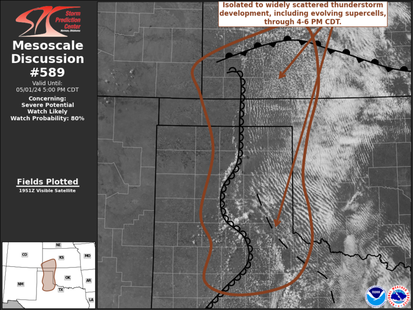
Mesoscale Discussion 0589
NWS Storm Prediction Center Norman OK
0257 PM CDT Wed May 01 2024

Areas affected...parts of northwest Texas and the Texas Panhandle
into southwestern Kansas

Concerning...Severe potential...Watch likely

Valid 011957Z - 012200Z

Probability of Watch Issuance...80 percent

SUMMARY...Isolated to widely scattered thunderstorm development
appears increasingly likely through 4-6 PM CDT, including the
evolution of supercells with potential to produce large hail in
excess of 2 inches in diameter, and a risk for tornadoes.

DISCUSSION...Deepening convective development is evident
south-southeast through northeast of Amarillo, along a sharpening
dryline that extends northward into southwestern Kansas near Garden
City.  To the east of this boundary, the western flank of a
boundary-layer air mass impacted by convective outflow appears to be
gradually modifying  across the eastern Texas Panhandle into the
Childress vicinity, in response to continuing isolation.

Aside from weak lower/mid-tropospheric warm advection, large-scale
forcing for ascent may remain weak to negligible into early evening,
and the warming aloft will contribute to increasing inhibition to
the east of the dryline.  However, with further surface heating, it
appears that the approach of convective temperatures along the
dryline and differential heating boundary will contribute to
increasing probabilities for isolated to widely scattered
thunderstorm development through 21-23Z.

With 60s to near 70F surface dew points contributing to large
mixed-layer CAPE on the order of 2000-3000 J/kg along the surface
boundaries, in the presence of steep lapse rates,  the environment
is becoming increasingly support of potential for supercells beneath
30-40 kt west-southwesterly flow around 500 mb.  Models suggest that
this may veer to more of a westerly component by early evening,
while modest southerly flow around 850 mb backs with time and
strengthens to around 30+ kt across the eastern Texas Panhandle.  As
this occurs, profiles appear likely to become increasingly
supportive of strengthening low-level mesocyclones with potential to
produce tornadoes.

Tornadic potential may become maximized with stronger cells tending
to propagate eastward and southeastward across the differential
heating boundary, before they tend to weaken as they encounter more
stable updraft inflow.  However, in the wake of this activity,
renewed vigorous thunderstorm development is likely to persist along
the stationary to slowly retreating dryline into early evening, with
a continuing risk for large hail and tornadoes.

..Kerr/Hart.. 05/01/2024

...Please see www.spc.noaa.gov for graphic product...

ATTN...WFO...OUN...DDC...LUB...AMA...PUB...

LAT...LON   34920202 36060177 37020206 37600219 38140090 38339969
            37339938 36359964 35579977 34949963 34299960 33650005
            33440120 33690192 34350178 34920202
SPC 2000Z Day 1 Outlook

Day 1 Convective Outlook
NWS Storm Prediction Center Norman OK
0314 PM CDT Wed May 01 2024

Valid 012000Z - 021200Z

...THERE IS AN ENHANCED RISK OF SEVERE THUNDERSTORMS THIS AFTERNOON
AND EVENING FROM SOUTH-CENTRAL KANSAS INTO WESTERN OKLAHOMA/WEST
TEXAS...

...SUMMARY...
The greatest threat today for large to very large hail, severe
thunderstorm gusts and a few tornadoes will be in from south-central
Kansas into western Oklahoma, the eastern Texas Panhandle and
northwest/west-central Texas.

...20Z Update...
Severe probabilities have been expanded westward somewhat to account
for a farther west position of the dryline this afternoon.
Significant wind probabilities have also been added across parts of
west/northwest TX, where a mix of supercell clusters and eventual
MCS development will be possible.

The influence of extensive antecedent convection remains quite
evident across parts of KS/OK, with the richest moisture currently
confined from far western OK into the eastern TX Panhandle and
northwest TX, and pockets of somewhat higher dewpoints from
southeast KS into northeast OK, and also across southwestern KS,
where somewhat stronger recovery is occurring this afternoon.

Confidence remains rather low regarding storm coverage and evolution
along the dryline, though at least isolated supercell development
will be possible late this afternoon into the evening, with a threat
of all severe hazards.

Upscale growth into one or more clusters still appears likely across
central and possibly north TX tonight, with some potential for an
organized MCS to move into southeast TX before the end of the
period. An elevated storm cluster and possible MCS is also expected
to develop near the KS/NE border later tonight. While this
convection will likely remain mostly elevated, rather strong MUCAPE
will support at least an isolated threat for both hail and severe
gusts. See the previous discussion below for more information, and
MCD 589 for more information regarding the short-term threat from
southwest KS into the TX Panhandle. .

..Dean.. 05/01/2024

.PREV DISCUSSION... /ISSUED 1125 AM CDT Wed May 01 2024/

...Southern KS/Western OK/TX Panhandle...
Late morning surface analysis shows a low near Guymon OK, with a
remnant outflow boundary from overnight storms extending southward
through the eastern TX Panhandle and across southern OK.  It is
unclear whether this boundary will wash out through the afternoon,
or be maintained by shower/thunderstorm activity over southwest OK.
Regardless, thunderstorms will form rapidly on the dryline from
southwest KS into the eastern TX Panhandle late this afternoon and
interact with the remnant boundary.  Supercells capable of very
large hail, damaging winds, and tornadoes are possible along this
corridor through the early evening.  There is a chance of a strong
tornado or two, but confidence in position is not high enough to
increase tornado probabilities at this time.

...West TX...
Strong heating will occur today west of the dryline over west TX,
leading to scattered intense storm development.  Initial discrete
supercells will pose a risk of very large hail and a few tornadoes,
but organized outflows appear likely given latest model guidance,
which will promote damaging wind gusts as storms spread eastward
through the evening.

...Central TX today and tonight...
A very moist low-level air mass is in place today over south-central
TX, with dewpoints well into the 70s.  Scattered afternoon
thunderstorms are expected to form in this environment, where
sufficient CAPE and deep-layer shear will promote
organized/supercell structures.  Given the abundant low-level
theta-e and veering low-level wind fields, a tornado or two is
possible, along with locally gusty/damaging winds.

Tonight, storms that form over west TX may organize into an MCS and
track into central TX.  A strengthening sub-tropical mid-level wind
max will help to sustain the activity, with a continued risk of
damaging winds overnight.

...Southern NE/Northern KS tonight...
Relatively widespread thunderstorms are expected to form after dark
over southwest NE/northwest KS ahead of an approaching shortwave
trough.  This activity will spread eastward overnight, with
sufficient (mainly) elevated CAPE to support hail and gusty winds in
the stronger cores.
SPC 1730Z Day 2 Outlook

Day 2 Convective Outlook
NWS Storm Prediction Center Norman OK
1230 PM CDT Wed May 01 2024

Valid 021200Z - 031200Z

...THERE IS A SLIGHT RISK OF SEVERE THUNDERSTORMS FROM SOUTHWEST OK
INTO NORTHWEST TX...

...SUMMARY...
Scattered strong to severe storms will be possible on Thursday from
parts of the upper Mississippi Valley into the southern Plains.

...Synopsis...
A relatively deep upper-level trough will persist over the
western/central CONUS on Thursday. Within the broader cyclonic flow,
multiple embedded shortwaves will move east-northeastward, both
within the main belt of flow across the central Plains into the
upper Great Lakes, and also within a southern stream across TX. The
surface pattern will be complicated by widespread overnight into
morning convection, but in general, a cold front is forecast to be
aligned from southwest TX toward parts of the Midwest. One surface
wave may move from the central Plains into the upper Great Lakes
region, while another weak surface low may persist across west TX.

While a rather broad and moist warm sector will support pockets of
severe potential on Thursday, uncertainty remains high due to
multiple rounds of extensive antecedent convection across the Great
Plains region.

...Southern Great Plains into the lower MS Valley...
An MCS may be ongoing over east/southeast TX Thursday morning. Some
severe potential may accompany this system near the upper TX to LA
Gulf Coast, and perhaps as far east as the lower MS Valley.

In the wake of the morning MCS, an outflow boundary may extend
across into parts of central/north TX, while the cold front to the
north is forecast to gradually weaken as it moves southeastward
across parts of OK into northwest TX. A dryline is forecast to
extend into southwest TX. Depending on the magnitude of diurnal
heating and outflow modification, isolated to widely scattered storm
development will be possible near all of these boundaries during the
afternoon/evening. Modest west-southwesterly flow aloft will support
sufficient effective shear for some storm organization, especially
where low-level flow remains backed.

Steep midlevel lapse rates will support moderate to locally strong
destabilization wherever stronger heating can occur. Isolated
supercell development will be possible initially, with a threat of
large hail (potentially greater than 2 inches in diameter) and
possibly a tornado. Depending on the extent of storm coverage,
modest upscale growth will be possible, with an attendant threat of
at least isolated damaging gusts.

A Slight Risk has been added from southwest OK into northwest TX,
where the best potential for strong diurnal destabilization is
currently expected, though uncertainty remains regarding storm
coverage in this area.

...Parts of MO into the upper MS Valley...
Uncertainty is high in this region as well, with some potential for
an MCS to be ongoing across parts of IA/MO/northwest IL during the
morning. An isolated damaging wind risk could accompany this system
in the morning, with some potential for redevelopment in its wake as
a weak surface wave moves toward the upper Great Lakes region.
Destabilization may be limited in the wake of morning convection,
but sufficient deep-layer shear and a moderate low-level jet will
support some potential for organized convection, and a couple
stronger cells/clusters could develop during the afternoon. While a
Marginal Risk has been maintained across this region, a corridor of
somewhat greater severe potential could evolve Thursday afternoon,
depending on the evolution of morning convection and recovery in its
wake.

..Dean.. 05/01/2024
SPC Day 2 Fire Weather Outlook

Day 2 Fire Weather Outlook
NWS Storm Prediction Center Norman OK
0258 PM CDT Wed May 01 2024

Valid 021200Z - 031200Z

...NO CRITICAL AREAS...

Trimmed the northeastern extent of the Elevated area across eastern
New Mexico based on forecast frontal position. Otherwise, no changes
are necessary. See previous forecast discussion below.

..Bentley.. 05/01/2024

.PREV DISCUSSION... /ISSUED 0147 AM CDT Wed May 01 2024/

...Synopsis...
Northwesterly flow is expected to strengthen across New Mexico on
Thursday, as a lee cyclone develops in the southern High Plains.
Sustained winds of 15 to 20 mph are expected with relative humidity
in the single digits. Deterministic guidance varies on how
widespread any critical wind speeds will be. This leads to low
confidence in including a Critical area with this outlook, but will
be monitored for future outlook updates. For now, Elevated to
locally Critical fire weather conditions are expected on Thursday.

...Please see www.spc.noaa.gov/fire for graphic product...
SPC Day 3-8 Fire Weather Outlook

Day 3-8 Fire Weather Outlook
NWS Storm Prediction Center Norman OK
0353 PM CDT Wed May 01 2024

Valid 031200Z - 091200Z

Relatively benign fire weather conditions are expected late this
week and over the weekend. However, by the end of the weekend and
into early next week a strong tough is expected to develop across
the western CONUS with strong mid-level flow across the Southwest
and lee cyclogenesis in the Plains. This will result in several days
of severe weather concern across portions of the southern High
Plains.

...D5/Sunday - Southern New Mexico....
Stronger mid-level flow will start to spread east on Sunday as the
western CONUS mid-level trough advances east. There is still some
uncertainty with timing of this trough and slightly faster timing
could lead to Critical fire weather conditions on Sunday.

...D6/Mon-D8/Wed - Eastern New Mexico and vicinity....
Critical fire weather conditions are likely across eastern New
Mexico and vicinity Monday/Day6 and Tuesday/Day7 as moderate to
strong mid-level flow overspreads the southern High Plains with a
deeply mixed airmass and very dry surface conditions expected. These
winds will be further supported by the tightening pressure gradient
from cyclogenesis in the Plains. Critical fire weather conditions
may continue for most of next week to Day 8 and beyond, but there is
enough model uncertainty to precede 70% Critical probabilities at
this time.

..Bentley.. 05/01/2024

...Please see www.spc.noaa.gov/fire for graphic product...
|